Settle
Our History
The name of Settle is thought to be Anglian 7th. century meaning a settlement, the Angles arrived in the area from the west around this time. A few centuries later the Norse-Irish moved into the area, also from the west, descendants of the earlier Scandinavian invasions of Ireland.
The name of Settle is thought to be Anglian 7th. century meaning a settlement, the Angles arrived in the area from the west around this time. A few centuries later the Norse-Irish moved into the area, also from the west, descendants of the earlier Scandinavian invasions of Ireland. So at the time of the Domesday Survey the area was already settled, though probably only sparsely, Bu was Lord of the Manor of Anley (the south-eastern edge of Settle parish), and had three caracutes of land for tax here and three in Settle. All the villages of today were known at that time by the same names, though rather different spellings, for instance Setel became Settle. But because of the rebellion of the north, between 1069 and 1071 the barons’ response was a campaign of genocide, burning and looting, so that much of the area was described as being “Waste” in the Domesday survey.
Until a church was built in 1838 Settle township was part of the ancient Parish of Giggleswick; this was an area of some 30 square miles including the townships of Langcliffe, Stainforth and Rathmell, as well as Settle and Giggleswick.
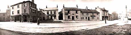
In 1249 Henry de Percy (1228-1272) obtained Settle’s first Market Charter from King Henry III to hold a market each Tuesday. From this time Settle grew as a place for local commerce and trading. New houses were built around the market square, and the north and west side appears to have been laid out in long strips, possibly as burgage plots. The main route through the medieval town was aligned on an east-west direction from what is now Albert Hill down Victoria Street, High Street and Cheapside and on through Kirkgate (the way to the ancient parish church at Giggleswick). The present road alignment of north-south came about when the Turnpike Keighley to Kendal road was put through in 1753, making more building land available.
The Cliffords of Skipton succeeded as Lords of the Manor and principal landowners in the area. The estates of Salley Abbey came into the hands of Sir Arthur Darcy, a land speculator. The old Soke Mill at Runley Bridge, Settle also went to speculators, which caused much resentment as they could charge the local people whatever price they fancied for grinding the corn.
At the time of the Civil War, the Cliffords were staunch Royalists and tenants of their land were expected to be likewise. But John Lambert of Calton in Malhamdale was a staunch Parliamentarian and rose to be a General in Cromwell’s Army. The area saw much movement of troops and some action, with General Lambert’s troops being encamped at Settle in August 1651, on their way to encounter the Royalist Army camped at Lancaster.
In earliest times the majority, if not all, the houses would have been built of wood and thatch, which of course meant they were prone to being burnt down. So naturally enough there are no remains of very early (pre-17th. century) houses in Settle. But we do know that there were early stone buildings in the area, such as Granges, barns and sheep houses, built by and for the monasteries. It seems likely though that once the market charter was obtained in the 13th. century, houses, shops and workshops would be built in any gaps around the square. The first mention of a bridge over the river Ribble is 1498 and this was certainly constructed of stone. At this time there would have been very little wheeled traffic as roads were practically non existent. The majority of goods coming into the area would be carried by pack horses over the numerous hillside tracks.
In the 17th. century Settle was prospering and expanding and the majority of houses were being built or rebuilt in stone. During this period many of the present houses and inns in Settle were new-built or refronted, some with Datestones proudly showing the owners’ initials, several with fine patterned carving.
The earliest houses were built with a mix of field-collected water-worn stones (glacial) and locally quarried rubble limestone, rather like a drystone wall, but with the joints filled with lime-mortar (slobbered) to make them stronger and more waterproof. Cut stone was normally used only for the corner quoins, window and door surrounds. Several of the oldest houses still have the heavy stone flag roof covering and the massive chimney stack that went with them. A few houses still have external chimney stacks and those with a curved lower section may denote a built-in oven.
In 1753 during the reign of George II the Turnpike Road from Keighley to Kendal was built, taking a route much lower in the valley of the Ribble and coming into Settle from the East into what was then a little dead end lane called Duck Street. This was made into the through route and renamed Duke Street. However the road still went down Kirkgate, also called Eagle Street at that time after the Spread Eagle Inn, as there was no other road to the west at that time. The Golden Lion which once faced the Market Square was realigned onto the new Duke Street so that Coach Traffic could be catered for. This was the start of the golden age for the Coaching Inns as the new Turnpike Roads opened up wheeled travel throughout the country.
Cotton Spinning was becoming the main employment for the local population with Runley Mill, Bridge End Mill and King’s Mill being either converted and extended from corn milling to cotton spinning, or being purpose built. John Procter operated mills at Runley and King’s Mill which were later taken over by his son Thomas. He later built the row of workers cottages now called Procter’s Row in lower Kirkgate. Baines History of the Cotton Manufacture (1835) gives Settle as having 5 mills employing 333 people at this time, the others being Dog Kennel Mill and Brennands weaving shed in upper Settle.
The North Western Railway was opened in 1847 with a station at Giggleswick. Two years later the railway company constructed a new Station Road from Giggleswick to Settle. It would be another 30+ years before the Settle/Carlisle Railway was built, with the line opening to goods traffic in 1875 and to passengers the following year. In 1876 the Station Building was opened along with goods warehouse, cattle pens, signal box and water cranes. The following year the Keighley-Kendal Turnpike Trust was wound up due to lack of tolls, the main shareholders losing quite a lot of money according to the records.
In 1856 the separate elementary boys and girls schools of Settle combined and moved into their present spacious premises in upper Settle, now the town’s primary school, though at present there are plans for a new school to be built on Bond Lane.
Later houses were built with cut sandstone/gritstone, some in watershot style, which could be neatly layered and mortared, and several of the finer houses were ashlar faced. On these later date houses the sandstone roofing slates used were thinner as new local quarries were opened and techniques improved for splitting the slate taken from them. Because of the work the North Craven Heritage Trust group carried out in the 1970s much of Settle is now designated as a conservation area, and many of the buildings are Grade II listed.
Phil & Rita Hudson. Hudson History, Kirkgate, Settle